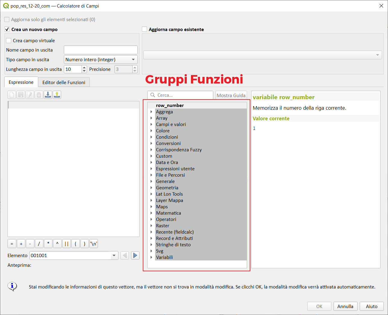
Gruppi funzioni↵
Nell'Interfaccia del Field Calc (e nel costruttore di espressione) è presente, nella parte centrale, una sezione che raccoglie i Gruppi delle Funzioni elencate sotto:
| Gruppo funzioni | nro funzioni* | Descrizione | info |
|---|---|---|---|
| Aggrega | (23/23) | Contiene funzioni che aggregano valori nei livelli e campi. | aggiornate a QGIS 3.36 |
| Array | (36/36) | Questo gruppo contiene funzioni espressione per la creazione e la manipolazione di array (noti anche come strutture dati ad elenco). L'ordine dei valori all'interno dell'array è importante, al contrario della struttura dati 'a mappa', in cui l'ordine delle coppie chiave-valore è irrilevante e i valori vengono identificati dalle loro chiavi. | aggiornate a QGIS 3.28 |
| Campi e valori | (1/1) | Contiene un elenco di campi del layer. Si possono ottenere valori campione con il click del tasto destro del mouse. Seleziona il nome del campo dall'elenco e fai click con il tasto destro per aprire il menù con le opzioni per caricare un campione di valori dal campo selezionato. | Elenco dei campi del layer selezionato QGIS 3.28 |
| Colore | (17/17) | Questo gruppo contiene funzioni per manipolare i colori | Per manipolare i colori |
| Condizioni | (6/6) | Questo gruppo contiene funzioni per gestire controlli condizionali nelle espressioni. | aggiornate a QGIS 3.6 |
| Conversioni | (15/15) | Questo gruppo contiene funzioni per convertire i dati da un tipo ad un altro, es. da stringa a intero, da intero a stringa. | aggiornate a QGIS 3.16 |
| Corrispondenza Fuzzy | (4/4) | Questo gruppo contiene funzioni per confronti fuzzy fra valori. | funzioni per confronti fuzzy fra valori |
| Custom | (16/16) | Questo gruppo contiene funzioni Python create in modo personalizzato dall'utente. | funzioni personalizzate |
| Data ora | (21/21) | Questo gruppo contiene funzioni per gestire dati con date e ore. | aggiornate a QGIS 3.14 |
| Espressioni utente | (?) | Questo gruppo contiene espressioni memorizzate nel profilo utente. | aggiornate a QGIS 3.12 |
| File e percorsi | (9/9) | Contiene funzioni che manipolano nomi di file e di percorsi. manipolano nomi di file e di percorsi | aggiornate a QGIS 3.22 |
| Form | (0/2) | Questo gruppo contiene funzioni che sono disponibili nel contesto modulo attributi. Per esempio, in impostazioni campo widget. Gruppo visibile solo nei widget. | aggiornate a QGIS 3.14 |
| Generale | (7/7) | Questo gruppo contiene funzioni generali assortite. | assortimento di funzioni generiche |
| Geometria | (151/151) | Questo gruppo contiene funzioni che operano sugli oggetti geometrici es. lunghezza, area. | aggiornate a QGIS 3.34 |
| Layer mappa | (3/3) | Contiene due funzioni e la lista dei layer della mappa che sono disponibili nel progetto corrente con possibilità di leggere1 i nomi e valori degli attributi. | aggiornate a QGIS 3.30 |
| Layout | (2/2) | Visibile solo nel layout di stampa | |
| Maps | (14/14) | Questo gruppo contiene funzioni per la creazione e la manipolazione di strutture di dati 'a mappa' (noti anche come oggetti dizionario, coppie chiave-valore o array associative). Si possono assegnare valori a determinate chiavi. L'ordine delle coppie chiave-valore nell'oggetto mappa non è rilevante. | >= QGIS 3.0 aggiornate a QGIS 3.24 |
| Matematica | (28/28) | Questo gruppo contiene funzioni matematiche es. radice quadrata, seno e coseno | aggiornate a QGIS 3.12 |
| Operatori | (23/23) | Questo gruppo contiene operatori es. + - * | aggiornate a QGIS 3.20 |
| Raster | (2/2) | Contiene funzioni che calcolano statistiche e valori raster. | >= QGIS 3.4 |
| Recente | (1/1) | Elenca le ultime 20 espressioni utilizzate | |
| Record e attributi | (17/17) | Questo gruppo contiene funzioni che operano sugli identificativi dei record. | aggiornate a QGIS 3.30 |
| Sensors | Questo gruppo contiene le funzioni per interagire con i sensori | a QGIS 3.30 |
|
| Relazioni | (?) | Visibile solo se ci sono relazioni di progetto | |
| Stringhe di testo | (25/25) | Questo gruppo contiene le funzioni che operano sulle stringhe es. sostituzione, conversione in maiuscolo. | aggiornate a QGIS 3.32 |
| Variabili | (4/65+) | Questo gruppo contiene variabili dinamiche che possono essere inserite nelle tue espressioni. | >= QGIS 2.12 - variano in funzione del contesto |
conteggio: https://gist.github.com/pigreco/2b2ad2eb12d17c4370b09635ae1470b4
* i numeri tra parentesi rappresentano: (numero funzioni documentate/numero funzioni nel gruppo)
espressione e tag↵
I tag sono utili per la ricerca delle espressioni:

| funzioni | tags |
|---|---|
| $geometry | current, processing, functions |
| $id | row, current |
| $length | distance, planimetric, length, perimeter, current, linestring, project, settings, ellipsoid, border, setting, calculated |
| $map | layout, item, drawn, current, main, print, map, window, overview, canvas |
| $page | layout, print, page, current |
| $perimeter | distance, planimetric, length, perimeter, current, polygon, project, settings, ellipsoid, setting, calculated |
| $rownum | row, number, current |
| $scale | denominator, contexts, current, scale, canvas, map |
| $vertex_as_point | point, mesh, vertex, current |
| $vertex_index | index, mesh, vertex, current |
| $vertex_x | coordinate, mesh, vertex, current |
| $vertex_y | coordinate, mesh, vertex, current |
| $vertex_z | mesh, vertex, current |
| $x | first, point, coordinate, current, multipoint |
| $x_at | current, retrieves, feature, coordinate |
| $y | first, point, coordinate, current, multipoint |
| $y_at | current, retrieves, feature, coordinate |
| $z | first, point, current, multipoint, altitude, 3D |
| % | division, remainder |
| * | multiplication, values |
| + | addition, null, result, values |
| - | subtraction, null, result, values |
| / | division, values |
| < | left, evaluates, compares, less, values, right |
| <= | compares, equal, less, values, left, evaluates, right |
| <> | compares, evaluates, values, equal |
| = | compares, evaluates, values, equal |
| AND | condition |
| CASE | casewhen, clause, series, met, first, corresponding, end, none, evaluated, components, conditions, optional, marks, return, evaluation, else, case, evaluate, result, stops, condition, set |
| ILIKE | compare, numbers, insensitive, first, match, sensitive, supplied, parameter, case, matches, pattern |
| IN | list, contained, found |
| IS | compare, same, equal, identical |
| IS NOT | compare, same, different |
| LIKE | compare, sensitive, numbers, first, works, supplied, parameter, matches, pattern |
| Meshes | calculate, functions, return, mesh, related, contains |
| NOT | negates, condition |
| NULL | equates, null |
| OR | condition |
| [] | array, operator, element, map, index |
| > | greater, compares, evaluates, left, values, right |
| >= | compares, equal, values, greater, left, evaluates, right |
| ^ | power, values |
| abs | absolute |
| acos | angle, cosine, inverse, radians |
| affine_transform | affine, coordinate, operations, spatial, transformation, reference, offset, system, calculations, translation, rotation, order, added, present, scale |
| age | difference, needs, datetimes, order, extract, information, following, interval, dates, functions, yearmonthweekdayhourminutesecond |
| aggregate | aggregate, combine, features, calculated, merge, concatenate, sum, mean, median, count, quartile, minimum, maximum, minority, majority, standard, deviation, length, unique |
| angle_at_vertex | angles, specified, clockwise, angle, linestring, degrees, bisector, north, average, vertex |
| apply_dash_pattern | dash, stroked, multilinestring, input, ring, specified, applies, line, pattern, returning |
| area | planimetric, polygon, spatial, reference, system, calculations, area, project, settings, surface, ellipsoid, units |
| array | list, array, parameter, containing |
| array_agg | array, field, aggregated |
| array_all | array, contains, compare, search |
| array_append | array, added, end |
| array_cat | concatenated, arrays, containing |
| array_distinct | array, containing, distinct |
| array_filter | array, items, limit, evaluates |
| array_find | array, found, first, lowest, index |
| array_first | array, first |
| array_foreach | evaluated, array, iterate, item |
| array_get | array, position, index, last, nth, one, first |
| array_insert | array, added, position |
| array_intersect | array, element, exists, intersection, overlap |
| array_last | array, last |
| array_length | elements, array, count |
| array_majority | common, array, median |
| array_max | array, maximum |
| array_mean | array, ignored, mean, numeric, arithmetic |
| array_median | array, arithmetic, median, ignored |
| array_min | array, minimum |
| array_minority | common, array, median |
| array_prepend | array, added, beginning |
| array_prioritize | sorted, array, first, specified, missing, second, ordering, added, present, result, end |
| array_remove_all | array, entries, removed |
| array_remove_at | array, removed, index |
| array_replace | array, map, replaced, supplied |
| array_reverse | array, reversed, order |
| array_slice | array, defined, arguments, start, position, slice, portion, end, index |
| array_sort | sorted, array, elements, provided |
| array_sum | array, ignored, numeric, arithmetic, sum |
| array_to_string | concatenates, delimiter, join, aggregate |
| ascii | code, first, associated, character, unicode |
| asin | sine, inverse, angle, radians |
| atan | tangent, inverse, angle, radians |
| atan2 | tangent, arguments, signs, angle, inverse, quadrant |
| attribute | attribute |
| attributes | attributes, names, field, keys, containing, map |
| azimuth | measured, clockwise, points, angle, vertical, north, azimuth, radians |
| base_file_name | suffix, base, directory, name, file, folder, path |
| boundary | polygon, linestrings, instance, combinatorial, topological, points, collections, types, ring, boundary, closure |
| bounds | box, input, spatial, reference, calculations, system, represents, bounding |
| bounds_height | box, spatial, reference, calculations, system, height, bounding |
| bounds_width | width, box, spatial, reference, calculations, system, bounding |
| buffer | distance, equal, spatial, reference, calculations, system, points, segments, miter, join, cap, round |
| buffer_by_m | line, according, values, varies, vertices, buffer, diameter |
| ceil | rounds, number |
| centroid | geometric, center |
| char | associated, character, unicode, code |
| clamp | specified, restricts, input, range |
| close_line | first, point, closed, end, input, appending, result, line, multi |
| closest_point | closest, point, nearest |
| coalesce | list, first, arguments, null |
| collect | aggregated, multipart |
| collect_geometries | part, set, collects, object, multi |
| color_cmyk | cyan, color, black, yellow, representation, components |
| color_cmyka | cyan, alpha, color, black, yellow, representation, components |
| color_grayscale_average | filter, color, provided, applies, grayscale, representation |
| color_hsl | attributes, lightness, color, hue, representation, saturation |
| color_hsla | attributes, alpha, lightness, color, transparency, hue, representation, saturation |
| color_hsv | attributes, color, hue, representation, saturation |
| color_hsva | attributes, alpha, color, transparency, hue, representation, saturation |
| color_mix_rgb | green, blue, red, alpha, mixing, color, colors, provided, ratio |
| color_part | red, specific, color, component, alpha |
| color_rgb | green, blue, red, color, representation, components |
| color_rgba | green, blue, red, alpha, color, representation, components |
| combine | combination, union |
| concat | empty, converted, numbers, concatenates, null, strings, several, other, values |
| concatenate | aggregated, field, joined, delimiter, strings |
| concatenate_unique | aggregated, unique, field, joined, delimiter, strings |
| contains | lie, point, lies, tests, interior, exterior, within, points, contains |
| convex_hull | hull, convex, minimum, represents, encloses, set |
| cos | angle, cosine |
| count | aggregate, features, matching, count |
| count_distinct | aggregate, distinct, count |
| count_missing | aggregate, missing, count |
| create_ramp | map, gradient, steps, strings, ramp, color |
| crosses | common, supplied, crosses, tests, interior, points |
| current_parent_value | field, actual, unsaved, wrapped, retrieve, widget, current, relation, differ, edited, embedded, coalesce, attribute, form, filter, added, features, parent, context, usable |
| current_value | table, field, actual, unsaved, current, differ, edited, row, attribute, form, added, features |
| darker | darker, color, lighter |
| datetime_from_epoch | passed, datetime, localtime, msecs, date, coordinated, converted, universal, milliseconds, time |
| day | date, extracts, interval, days, number, day |
| day_of_week | week, day, specified, datetime, corresponds, ranges, date, saturday |
| decode_uri | depends, layer, data, dataprovider, provider, uri, underlying, decodes, available |
| degrees | converts, degrees, radians |
| densify_by_count | generates, layer, line, number, one, new, polygon, vertices, larger, original |
| densify_by_distance | maximum, edges, additional, generates, line, densified, adding, new, polygon, interval, layer, one, distance, vertices, specified |
| difference | part, represents, intersect, clip |
| disjoint | share, intersect, tests, space |
| display_expression | evaluated, arguments, details, display, default |
| distance | projected, reference, spatial, minimum, units |
| distance_to_vertex | distance, specified, vertex |
| end_point | last, node, vertex |
| env | operating, content, prefixes, gets, definition, found, drive, check, system, environment, path, variables, letters, inject, specific, configuration, depends, administrator, variable, documentation, handy, set |
| epoch | interval, date, milliseconds, epoch |
| eval | dynamic, fields, parameters, expression, expand, context, passed, variables, evaluates |
| eval_template | dynamic, fields, parameters, template, expand, context, passed, variables, evaluates |
| exif | exif, retrieves, tag, file, image, values |
| exif_geotag | geotags, exif, point, file, image |
| exp | exponential |
| extend | start, distances, line, last, linestring, amount, parts, bearing, lines, extends, reference, spatial, extended, first, segment, system, multilinestring, specified, end |
| exterior_ring | polygon, line, ring, exterior, result, representing |
| extrude | curve, version, extension, input, specified, extruded, linestring, multi |
| file_exists | path, exists, file |
| file_name | extension, name, directory, file, path |
| file_path | path, directory, name, folder, file |
| file_size | size, file, bytes |
| file_suffix | extension, path, suffix, file |
| flip_coordinates | latitude, longitude, reversed, swapped, coordinates, repairing, copy |
| floor | downwards, rounds, number |
| force_polygon_ccw | exterior, clockwise, respect, convention, rings, counter, interior, forces |
| force_polygon_cw | exterior, clockwise, respect, convention, rings, interior, counter, forces |
| force_rhr | contexts, clockwise, boundary, interior, rings, bounded, force_polygon_cw, explicit, polygon, area, exterior, inconsistency, right, use, hand, particular, respect, counter, forces, ring, recommended, oriented, direction, rule, definition |
| format | format, supplied, arguments |
| format_date | custom, type, uses, format, strings, time, date, formats, see, qdatetime, tostring |
| format_number | formatted, truncates, places, separator, decimal, default, thousands, locale, language |
| from_base64 | encoding, base, binary, decodes |
| from_json | json, loads, formatted |
| generate_series | sequence, containing, numbers, array |
| geom_from_gml | representation, conversion |
| geom_from_wkb | created, wkb, binary, known, representation, conversion |
| geom_from_wkt | text, known, wkt, representation, conversion |
| geom_to_wkb | wkb, binary, representation, known, conversion |
| geom_to_wkt | text, wkt, srid, representation, known, conversion |
| geometry | |
| geometry_n | part, input, multipart, collection, specific |
| geometry_type | describing, type, point, polygon, line |
| get_feature | attribute, first, matching, search, find |
| get_feature_by_id | |
| hamming_distance | distance, length, input, sensitive, different, strings, corresponding, hamming, equates, characters, case, same, comparison, positions |
| hash | hex, bytes, byte, digits, hash, method, given, represented, character, long, bits, produces |
| hausdorff_distance | distance, segment, dissimilar, densify, linestrings, parallel, other, matching, total, close, executed, specifying, occurs, equal, fraction, testing, method, discrete, linear, default, approximate, sets, length, large, lower, similar, similarity, parameter, measure, split, make, approach, closest, examples, provided, performs, insufficient, networks, specify, optional, decreasing, approximation, cases, densification, specified, computing, argument, subsegments, hausdorff, exact, indicating, subset, standard |
| hour | extracts, number, time, part, interval, hours, hour, datetime |
| hstore_to_map | formatted, hstore, map |
| if | tests, different, check, result, conditional, depending, condition |
| inclination | zenith, nadir, inclination, measured, points |
| interior_ring_n | interior, polygon, hole, ring |
| intersection | shared, represents, portion, overlap |
| intersects | share, space, intersects, tests, intersect, portion, overlaps |
| intersects_bbox | box, tests, overlaps, defined, intersect, bounding |
| iqr | field, quartile, range, inter, calculated, statistics, aggregates |
| is_closed | points, start, closed, end, coincident, result, false, line |
| is_directory | path, directory, folder |
| is_empty | empty, is_empty_or_null, see, coordinates, false |
| is_empty_or_null | empty, is_empty, coordinates, false |
| is_file | path, file |
| is_layer_visible | specified, visible |
| is_multipart | type, multi |
| is_selected | selected, arguments, details |
| is_valid | rules, valid, ogc, according, formed |
| item_variables | layout, item, variables, print, map |
| layer_property | property, matching, metadata |
| left | first, substring, leftmost, characters, contains, extracts |
| length | distance, linestring, length, count, characters, planimetric |
| length3D | planimetric, distance, length, spatial, reference, system, calculations, calculates, line, project, differs, object, match, settings, ellipsoid, units |
| levenshtein | distance, required, edit, indicate, sensitive, similarity, insertions, similar, mean, measure, different, character, change, substitutions, strings, edits, distances, larger, deletions, equates, case, minimum, levenshtein, smaller |
| lighter | darker, color, lighter |
| line_interpolate_angle | distance, angles, parallel, specified, clockwise, angle, linestring, degrees, north |
| line_interpolate_point | distance, interpolated, linestring, point, specified, along |
| line_locate_point | distance, point, specified, closest, linestring, position, corresponding, along |
| line_merge | passed, single, return, input, linestrings, merged, connected, linestring, multilinestring |
| line_substring | curve, start, specified, measured, falls, existing, interpolated, beginning, distances, line, end, portion |
| ln | natural, logarithm |
| log | base, logarithm |
| log10 | base, logarithm |
| longest_common_substring | longest, common, input, sensitive, case, substring, strings |
| lower | converts, letters, lower, case |
| lpad | length, padded, width, truncated, specified, target, fill, left, character, smaller |
| m | point, measure |
| m_max | maximum, measure |
| m_min | minimum, measure |
| main_angle | oriented, minimal, covers, clockwise, angle, long, north, degrees, rectangle, axis, bounding |
| majority | occurring, field, majority, aggregate |
| make_circle | circular, polygon |
| make_date | year, date, month, numbers, day |
| make_datetime | minute, month, numbers, day, year, second, hour, datetime |
| make_ellipse | polygon, elliptical |
| make_interval | minute, seconds, month, year, weeks, values, interval, hours, days |
| make_line | point, line, series |
| make_point | optional, point |
| make_point_m | point, coordinate |
| make_polygon | outer, ring, series, inner, optional, polygon |
| make_rectangle_3points | rectangle, points |
| make_regular_polygon | polygon, regular |
| make_square | square, diagonal |
| make_time | minute, hour, second, numbers, time |
| make_triangle | triangle, polygon |
| map | passed, keys, pair, containing, parameters, map |
| map_akeys | array, map, keys |
| map_avals | array, map |
| map_concat | containing, key, concatenate, contain, entries, maps, map |
| map_credits | list, rights, layers, layout, item, usage, credit, strings, map |
| map_delete | deleted, corresponding, map, key |
| map_exist | map, exists, key |
| map_get | map, exists, key |
| map_insert | map, added, exists, key, overridden |
| map_prefix_keys | prefixed, keys, map |
| map_to_hstore | formatted, hstore, elements, map, merge |
| maptip | evaluated, arguments, maptip, details, default, see |
| max | longest, biggest, most, largest, maximum |
| max_length | length, maximum, strings, characters, count, aggregate |
| maximum | maximum, aggregate |
| md5 | hash |
| mean | average, aggregate, mean |
| median | median, aggregate |
| mime_type | type, data, binary |
| min | least, smallest, minimum |
| min_length | length, characters, count, minimum, strings |
| minimal_circle | enclosing, minimal, minimum, represents, encloses, circle, smallest |
| minimum | minimum, aggregate |
| minority | least, occurring, field, minority, aggregate |
| minute | minutes, extracts, part, interval, number, time, datetime |
| month | date, extracts, months, part, interval, month, number |
| nodes_to_points | vertex, multipoint, node, input |
| now | static, evaluating, current, date, time |
| nullif | substitute, equals, condition, compare |
| num_geometries | collection, multipart, parts, count |
| num_interior_rings | rings, holes, count, polygon, collection, interior |
| num_points | vertices |
| num_rings | rings, holes, polygon, collection, exterior, including |
| num_selected | evaluated, selected, works, default, features |
| offset_curve | spatial, offsetting, reference, system, linestring, formed, distances, side |
| order_parts | criteria, multigeometry, orders, parts, given |
| oriented_bbox | oriented, box, minimal, represents, bounding |
| overlaps | share, tests, contained, overlaps, same, dimension, space |
| overlay_contains | least, predicate, current, contained, target, contains, array, geos, st_contains, postgis, described, underlying, features |
| overlay_crosses | predicate, st_crosses, crosses, current, target, array, geos, described, underlying, features, crossed |
| overlay_disjoint | predicate, st_disjoint, disjoint, current, target, array, geos, described, underlying, features |
| overlay_equals | predicate, current, equals, equal, target, array, geos, st_equals, described, underlying, features |
| overlay_intersects | intersected, least, predicate, current, target, array, geos, postgis, described, st_intersects, intersects, underlying, features |
| overlay_nearest | distance, layers, large, slow, current, target, array, lot, features |
| overlay_touches | least, predicate, touches, current, target, array, geos, described, underlying, touched, st_touches, features |
| overlay_within | predicate, current, contain, target, array, geos, described, underlying, features |
| parameter | algorithm, parameter, processing |
| perimeter | planimetric, distance, polygon, perimeter, spatial, reference, system, calculations, project, differs, object, match, settings, ellipsoid, units |
| pi | calculations, pi |
| point_n | specific, node, vertex |
| point_on_surface | point, surface, lie, centroid, overlay |
| pole_of_inaccessibility | inaccessibility, precise, tolerances, calculates, guaranteed, boundary, require, point, true, iterations, internal, uses, approximate, approach, polylabel, find, distant, calculate, pole, take, surface, specified, tolerance, iterative |
| project | distance, elevation, projected, start, point, azimuth, radians, bearing |
| project_color | scheme, project, color |
| q1 | field, quartile, first, calculated |
| q3 | third, field, quartile, calculated |
| radians | converts, degrees, radians |
| ramp_color | ramp, color, representing |
| rand | random, inclusive, specified, range, argument, seed, same, provided, minimum, maximum, integer, depending |
| randf | random, specified, range, argument, seed, same, provided, float, minimum, maximum, inclusive, depending |
| range | field, range, aggregate, minimum, maximum |
| raster_statistic | raster, statistics |
| raster_value | provided, point, raster, found |
| regexp_match | return, found, matching, unicode, regular, position, substring, first |
| regexp_matches | array, groups, capturing, captured, order, appear, supplied, regular, strings |
| regexp_replace | regular, supplied, replaced |
| regexp_substr | regular, matches, supplied, portion |
| relate | dimensional, relationship, extended, intersection, representation, model, tests |
| relation_aggregate | child, matching, aggregate, features, relation |
| replace | array, map, strings, supplied, replaced |
| represent_attributes | attributes, keys, arguments, representation, map, see, attribute, configured, names, type, details, depends, widget |
| represent_value | depends, configured, field, type, widgets, map, representation, widget |
| reverse | direction, order, vertices, reverses, line, reversing |
| right | last, substring, rightmost, characters, contains |
| rotate | version, spatial, reference, calculations, rotated, system |
| round | rounds, places, decimal, number |
| roundness | polygon, perfect, flat, close, shape, calculates, circle |
| rpad | length, right, padded, width, specified, truncated, target, fill, character, smaller |
| scale | version, scaled, spatial, reference, calculations, system |
| scale_exp | exponential, curve, ease, transforms, output, given, input, domain, range, specified, values |
| scale_linear | transforms, linear, output, given, input, domain, range, interpolation |
| second | extracts, part, seconds, interval, number, time, datetime |
| segments_to_lines | consisting, segment, input, multi, line |
| set_color_part | alpha, component, specific, red, color, sets |
| sha256 | hash |
| shortest_line | start, resultant, joining, end, shortest, line |
| simplify | straight, large, deviations, nodes, algorithm, reduces, simplifies, segments, number, threshold, distance, removing, vertices, based, preserves |
| simplify_vw | spikes, areas, straight, nodes, algorithm, area, simplifies, removes, narrow, segments, visvalingam, threshold, create, vertices, removing, based, small |
| sin | sine, angle |
| single_sided_buffer | buffering, spatial, reference, system, linestring, formed, distances, side |
| sinuosity | curve, distance, length, endpoints, sinuosity, ratio, straight |
| smooth | adding, corners, smoothed, dimensionality, round, output, contain, input, retain, extra, smooths, nodes, values, same |
| soundex | code, represented, similar, matching, algorithm, soundex, same, phonetic, representation, strings, sounds |
| sqlite_fetch_and_increment | attributes, children, applied, uncommitted, works, relations, prefetched, intended, creating, several, auto_increment, form, databases, transaction, parents, filter_value, mode, open, primary, evaluate, sidenote, add, require, impossible, default_values, table, insert, nice, formats, current, adding, get, target, work, specified, usage, columns, retrieved, autoincrementing, new, limitation, gpkg, parallel, database, additional, makes, postgres, modifies, sequence, cached, manage, key, same, id_field, acquire, filtered, default, filter_attribute, parent, option, unsafe, sqlite, separate, parameter, map, row, configurations, lifetime, processes, incremented, able, features, purpose |
| sqrt | root, square |
| square_wave | waves, rectangular, constructs, square, boundary |
| square_wave_randomized | waves, rectangular, constructs, square, boundary, randomized |
| start_point | first, node |
| stdev | deviation, field, standard, aggregate |
| straight_distance_2d | distance, curve, circularstring, first, last, direct, euclidean, linestring, vertex |
| string_to_array | split, convert, separate, delimiter, divides |
| strpos | substring, position, return, found, first, matching |
| substr | part |
| sum | field, summed, aggregate |
| sym_difference | portions, represents, intersect |
| tan | angle, tangent |
| tapered_buffer | varies, buffer, line, diameter, length |
| title | letter, words, lower, converts, leading, capital, title, case |
| to_base64 | encoding, base, binary, encodes |
| to_date | provided, additional, user, format_date, parse, qdate, converts, default, current, format, object, fromstring, date, optional, documentation, see |
| to_datetime | provided, additional, user, format_date, parse, qdate, converts, default, datetime, current, format, object, fromstring, optional, documentation, qtime, see |
| to_decimal | converts, minute, degree, equivalent, second, coordinate, decimal |
| to_dm | converts, minute, degree, coordinate |
| to_dms | converts, minute, degree, second, coordinate |
| to_int | converts, invalid, converted, integer |
| to_interval | type, month, converts, date, interval, take, hours, days |
| to_json | formatted, json, array, create, other, map |
| to_real | converts, precision, invalid, rounded, numbers, changes, real, result, converted, saving, conversion, smaller |
| to_string | converts, number |
| to_time | provided, additional, format, object, parse, time, converts, fromstring, optional, documentation, qtime, see |
| touches | point, common, touches, interiors, tests, intersect |
| transform | crs, source, transformed, destination, reprojection |
| translate | spatial, reference, calculations, system, translated, displace, move |
| triangular_wave | waves, boundary, constructs, triangular |
| triangular_wave_randomized | waves, boundary, constructs, randomized, triangular |
| trim | removes, leading, whitespace, spaces, tabs, trailing |
| try | return, tries, error, alternative, provided, exception |
| union | union, dissolve, point, represents, set |
| upper | converts, upper, letters, case |
| url_encode | encoded, producing, form, characters, query, plus, url, compliant, converted, map, sign, transforms |
| uuid | createuuid, generates, method, unique, quuid, identifier, row |
| var | stored, variable, specified |
| wave | waves, rounded, sine, boundary, constructs |
| wave_randomized | waves, sine, boundary, curved, constructs, randomized |
| wedge_buffer | buffer, wedge, point, originating, shaped |
| week | weeks, week, date, extracts, interval, number |
| with_variable | variable, argument, value, evaluation |
| within | tests, contains, completely |
| wordwrap | maximum, minimum, wrapped, characters, multiline |
| x | centroid, point, coordinate |
| x_max | coordinate, spatial, reference, calculations, system, maximum |
| x_min | coordinate, spatial, reference, calculations, system, minimum |
| y | centroid, point, coordinate |
| y_max | coordinate, spatial, reference, calculations, system, maximum |
| y_min | coordinate, spatial, reference, calculations, system, minimum |
| year | year, years, date, extracts, part, interval, number |
| z | point, coordinate |
| z_max | coordinate, maximum |
| z_min | coordinate, minimum |
| || | behavior, different, see, concat, null, joins, result, values |
| ~ | white, space, regular, performs, backslash, characters, escaped, character, expression, match |
tag e espressioni↵
| tag | espressioni |
|---|---|
| geometry, get_feature_by_id | |
| absolute | abs |
| adding | smooth, sqlite_fetch_and_increment, densify_by_distance |
| corners | smooth |
| smoothed | smooth |
| dimensionality | smooth |
| round | smooth, buffer |
| output | smooth, scale_exp, scale_linear |
| contain | smooth, map_concat, overlay_within |
| input | smooth, bounds, segments_to_lines, extrude, apply_dash_pattern, hamming_distance, scale_exp, close_line, longest_common_substring, geometry_n, line_merge, clamp, scale_linear, nodes_to_points |
| retain | smooth |
| extra | smooth |
| smooths | smooth |
| nodes | smooth, simplify_vw, simplify |
| values | smooth, +, |
| same | smooth, sqlite_fetch_and_increment, soundex, IS NOT, IS, hamming_distance, rand, randf, overlaps |
| addition | + |
| null | +, |
| result | +, |
| affine | affine_transform |
| coordinate | affine_transform, x, y, to_dm, to_decimal, to_dms, z_max, $vertex_x, $vertex_y, z_min, x_max, y_max, x_min, y_min, $x_at, $y_at, $x, $y, make_point_m, z |
| operations | affine_transform |
| spatial | affine_transform, bounds, bounds_height, single_sided_buffer, x_max, y_max, x_min, y_min, buffer, length3D, perimeter, area, distance, offset_curve, translate, extend, scale, rotate, bounds_width |
| transformation | affine_transform |
| reference | affine_transform, bounds, bounds_height, single_sided_buffer, x_max, y_max, x_min, y_min, buffer, length3D, perimeter, area, distance, offset_curve, translate, extend, scale, rotate, bounds_width |
| offset | affine_transform |
| system | affine_transform, bounds, bounds_height, single_sided_buffer, x_max, y_max, x_min, y_min, buffer, env, length3D, perimeter, area, offset_curve, translate, extend, scale, rotate, bounds_width |
| calculations | affine_transform, bounds, bounds_height, pi, x_max, y_max, x_min, y_min, buffer, length3D, perimeter, area, translate, scale, rotate, bounds_width |
| translation | affine_transform |
| rotation | affine_transform |
| order | affine_transform, regexp_matches, array_reverse, age, reverse |
| added | affine_transform, array_prepend, array_append, array_insert, current_parent_value, map_insert, array_prioritize, current_value |
| present | affine_transform, array_prioritize |
| scale | affine_transform, $scale |
| aggregate | aggregate, count_distinct, count, count_missing, mean, relation_aggregate, array_to_string, stdev, range, sum, minority, max_length, maximum, median, minimum, majority |
| combine | aggregate |
| features | aggregate, count, sqlite_fetch_and_increment, relation_aggregate, overlay_nearest, num_selected, current_parent_value, overlay_intersects, overlay_contains, overlay_touches, overlay_within, overlay_equals, overlay_crosses, overlay_disjoint, current_value |
| calculated | aggregate, $length, $perimeter, q1, iqr, q3 |
| merge | aggregate, map_to_hstore |
| concatenate | aggregate, map_concat |
| sum | aggregate, array_sum |
| mean | aggregate, array_mean, mean, levenshtein |
| median | aggregate, array_median, array_majority, array_minority, median |
| count | aggregate, count_distinct, count, count_missing, num_geometries, length, array_length, min_length, max_length, num_interior_rings |
| quartile | aggregate, q1, iqr, q3 |
| minimum | aggregate, array_min, z_min, x_min, y_min, levenshtein, minimal_circle, range, convex_hull, min, min_length, wordwrap, minimum, m_min, distance, rand, randf |
| maximum | aggregate, array_max, z_max, x_max, y_max, range, max_length, max, maximum, densify_by_distance, m_max, wordwrap, rand, randf |
| minority | aggregate, minority |
| majority | aggregate, majority |
| standard | aggregate, stdev, hausdorff_distance |
| deviation | aggregate, stdev |
| length | aggregate, sinuosity, hamming_distance, length, $length, $perimeter, hausdorff_distance, min_length, max_length, lpad, rpad, length3D, tapered_buffer |
| unique | aggregate, concatenate_unique, uuid |
| distinct | count_distinct, array_distinct |
| matching | count, get_feature, relation_aggregate, soundex, hausdorff_distance, layer_property, regexp_match, strpos |
| missing | count_missing, array_prioritize |
| aggregated | concatenate, collect, concatenate_unique, array_agg |
| field | concatenate, concatenate_unique, array_agg, attributes, represent_value, stdev, current_parent_value, q1, iqr, range, sum, minority, majority, current_value, q3 |
| joined | concatenate, concatenate_unique |
| delimiter | concatenate, concatenate_unique, array_to_string, string_to_array |
| strings | concatenate, concatenate_unique, regexp_matches, replace, soundex, format_date, hamming_distance, levenshtein, concat, min_length, max_length, map_credits, longest_common_substring, create_ramp |
| multipart | collect, num_geometries, geometry_n |
| algorithm | parameter, soundex, simplify_vw, simplify |
| parameter | parameter, sqlite_fetch_and_increment, ILIKE, LIKE, hausdorff_distance, array |
| processing | parameter, $geometry |
| alpha | set_color_part, color_hsva, color_hsla, color_cmyka, color_rgba, color_mix_rgb, color_part |
| component | set_color_part, color_part |
| specific | set_color_part, env, geometry_n, color_part, point_n |
| red | set_color_part, color_rgba, color_mix_rgb, color_rgb, color_part |
| color | set_color_part, color_hsva, color_hsla, color_hsv, color_hsl, color_cmyka, color_cmyk, darker, lighter, color_grayscale_average, color_rgba, color_mix_rgb, color_rgb, create_ramp, ramp_color, color_part, project_color |
| sets | set_color_part, hausdorff_distance |
| angle | cos, acos, tan, angle_at_vertex, line_interpolate_angle, azimuth, main_angle, sin, asin, atan2, atan |
| cosine | cos, acos |
| inverse | acos, asin, atan2, atan |
| radians | acos, degrees, radians, project, azimuth, asin, atan |
| tangent | tan, atan2, atan |
| angles | angle_at_vertex, line_interpolate_angle |
| specified | angle_at_vertex, sqlite_fetch_and_increment, line_substring, extrude, apply_dash_pattern, line_interpolate_angle, line_interpolate_point, line_locate_point, hausdorff_distance, distance_to_vertex, scale_exp, pole_of_inaccessibility, lpad, rpad, densify_by_distance, rand, randf, array_prioritize, clamp, is_layer_visible, extend, var, day_of_week |
| clockwise | angle_at_vertex, force_rhr, line_interpolate_angle, force_polygon_ccw, force_polygon_cw, azimuth, main_angle |
| linestring | angle_at_vertex, single_sided_buffer, extrude, line_interpolate_angle, straight_distance_2d, line_interpolate_point, length, $length, line_locate_point, line_merge, offset_curve, extend |
| degrees | angle_at_vertex, degrees, radians, line_interpolate_angle, main_angle |
| bisector | angle_at_vertex |
| north | angle_at_vertex, line_interpolate_angle, azimuth, main_angle |
| average | angle_at_vertex, mean |
| vertex | angle_at_vertex, $vertex_x, $vertex_y, straight_distance_2d, distance_to_vertex, $vertex_index, end_point, $vertex_z, $vertex_as_point, point_n, nodes_to_points |
| array | array_prepend, array_append, array_insert, array_median, array_distinct, array_all, array_slice, array_intersect, array_remove_all, array_agg, array_first, array_find, regexp_matches, array_mean, array_sum, array_filter, array_last, map_avals, map_akeys, array_replace, replace, array_max, array_min, [], array_get, array_remove_at, array_reverse, array_majority, array_minority, overlay_nearest, array_length, array_foreach, to_json, overlay_intersects, overlay_contains, overlay_touches, array, overlay_within, overlay_equals, overlay_crosses, overlay_disjoint, generate_series, array_sort, array_prioritize |
| beginning | array_prepend, line_substring |
| end | array_append, array_slice, CASE, line_substring, close_line, is_closed, array_prioritize, extend, shortest_line |
| position | array_insert, array_slice, array_get, line_locate_point, regexp_match, strpos |
| arithmetic | array_median, array_mean, array_sum |
| ignored | array_median, array_mean, array_sum |
| containing | array_distinct, attributes, array_cat, map_concat, array, map, generate_series |
| contains | array_all, Meshes, left, right, overlay_contains, contains, within |
| compare | array_all, ILIKE, IS NOT, IS, LIKE, nullif |
| search | array_all, get_feature |
| defined | array_slice, intersects_bbox |
| arguments | array_slice, represent_attributes, display_expression, maptip, format, coalesce, is_selected, atan2 |
| start | array_slice, line_substring, project, is_closed, extend, shortest_line |
| slice | array_slice |
| portion | array_slice, line_substring, regexp_substr, intersects, intersection |
| index | array_slice, array_find, [], array_get, array_remove_at, $vertex_index |
| element | array_intersect, [] |
| exists | array_intersect, map_insert, map_exist, map_get, file_exists |
| intersection | array_intersect, relate |
| overlap | array_intersect, intersection |
| entries | array_remove_all, map_concat |
| removed | array_remove_all, array_remove_at |
| first | array_first, array_find, array_get, get_feature, CASE, ascii, ILIKE, LIKE, straight_distance_2d, q1, start_point, close_line, $x, $y, $z, left, coalesce, regexp_match, array_prioritize, extend, strpos |
| found | array_find, IN, env, raster_value, regexp_match, strpos |
| lowest | array_find |
| groups | regexp_matches |
| capturing | regexp_matches |
| captured | regexp_matches |
| appear | regexp_matches |
| supplied | regexp_matches, array_replace, replace, crosses, ILIKE, LIKE, format, regexp_substr, regexp_replace |
| regular | regexp_matches, make_regular_polygon, regexp_substr, regexp_replace, regexp_match, ~ |
| numeric | array_mean, array_sum |
| items | array_filter |
| limit | array_filter |
| evaluates | array_filter, <=, >=, =, <>, eval, eval_template, >, < |
| last | array_last, array_get, straight_distance_2d, end_point, right, extend |
| map | map_avals, map_akeys, array_replace, replace, [], sqlite_fetch_and_increment, represent_attributes, attributes, map_concat, map_delete, $scale, represent_value, url_encode, map_to_hstore, hstore_to_map, to_json, $map, item_variables, map_credits, map_insert, map_exist, map_get, create_ramp, map, map_prefix_keys |
| keys | map_akeys, represent_attributes, attributes, map, map_prefix_keys |
| replaced | array_replace, replace, regexp_replace |
| operator | [] |
| nth | array_get |
| one | array_get, densify_by_count, densify_by_distance |
| reversed | array_reverse, flip_coordinates |
| associated | char, ascii |
| character | char, ascii, levenshtein, hash, lpad, rpad, ~ |
| unicode | char, ascii, regexp_match |
| code | char, ascii, soundex |
| attribute | attribute, get_feature, represent_attributes, current_parent_value, current_value |
| find | get_feature, pole_of_inaccessibility |
| attributes | color_hsva, color_hsla, sqlite_fetch_and_increment, color_hsv, represent_attributes, color_hsl, attributes |
| transparency | color_hsva, color_hsla |
| hue | color_hsva, color_hsla, color_hsv, color_hsl |
| representation | color_hsva, color_hsla, color_hsv, represent_attributes, color_hsl, soundex, geom_from_wkb, color_cmyka, color_cmyk, represent_value, relate, color_grayscale_average, color_rgba, color_rgb, geom_from_gml, geom_from_wkt, geom_to_wkt, geom_to_wkb |
| saturation | color_hsva, color_hsla, color_hsv, color_hsl |
| lightness | color_hsla, color_hsl |
| children | sqlite_fetch_and_increment |
| applied | sqlite_fetch_and_increment |
| uncommitted | sqlite_fetch_and_increment |
| works | sqlite_fetch_and_increment, LIKE, num_selected |
| relations | sqlite_fetch_and_increment |
| prefetched | sqlite_fetch_and_increment |
| intended | sqlite_fetch_and_increment |
| creating | sqlite_fetch_and_increment |
| several | sqlite_fetch_and_increment, concat |
| auto_increment | sqlite_fetch_and_increment |
| form | sqlite_fetch_and_increment, url_encode, current_parent_value, current_value |
| databases | sqlite_fetch_and_increment |
| transaction | sqlite_fetch_and_increment |
| parents | sqlite_fetch_and_increment |
| filter_value | sqlite_fetch_and_increment |
| mode | sqlite_fetch_and_increment |
| open | sqlite_fetch_and_increment |
| primary | sqlite_fetch_and_increment |
| evaluate | sqlite_fetch_and_increment, CASE |
| sidenote | sqlite_fetch_and_increment |
| add | sqlite_fetch_and_increment |
| require | sqlite_fetch_and_increment, pole_of_inaccessibility |
| impossible | sqlite_fetch_and_increment |
| default_values | sqlite_fetch_and_increment |
| table | sqlite_fetch_and_increment, current_value |
| insert | sqlite_fetch_and_increment |
| nice | sqlite_fetch_and_increment |
| formats | sqlite_fetch_and_increment, format_date |
| current | sqlite_fetch_and_increment, $vertex_x, $vertex_y, $geometry, $x_at, $y_at, $scale, overlay_nearest, $length, $perimeter, current_parent_value, $x, $y, $z, $vertex_index, overlay_intersects, $map, $page, overlay_contains, overlay_touches, $vertex_z, $vertex_as_point, overlay_within, overlay_equals, overlay_crosses, overlay_disjoint, to_date, to_datetime, $id, $rownum, now, current_value |
| get | sqlite_fetch_and_increment |
| target | sqlite_fetch_and_increment, overlay_nearest, overlay_intersects, overlay_contains, overlay_touches, lpad, rpad, overlay_within, overlay_equals, overlay_crosses, overlay_disjoint |
| work | sqlite_fetch_and_increment |
| usage | sqlite_fetch_and_increment, map_credits |
| columns | sqlite_fetch_and_increment |
| retrieved | sqlite_fetch_and_increment |
| autoincrementing | sqlite_fetch_and_increment |
| new | sqlite_fetch_and_increment, densify_by_count, densify_by_distance |
| limitation | sqlite_fetch_and_increment |
| gpkg | sqlite_fetch_and_increment |
| parallel | sqlite_fetch_and_increment, line_interpolate_angle, hausdorff_distance |
| database | sqlite_fetch_and_increment |
| additional | sqlite_fetch_and_increment, densify_by_distance, to_time, to_date, to_datetime |
| makes | sqlite_fetch_and_increment |
| postgres | sqlite_fetch_and_increment |
| modifies | sqlite_fetch_and_increment |
| sequence | sqlite_fetch_and_increment, generate_series |
| cached | sqlite_fetch_and_increment |
| manage | sqlite_fetch_and_increment |
| key | sqlite_fetch_and_increment, map_concat, map_delete, map_insert, map_exist, map_get |
| id_field | sqlite_fetch_and_increment |
| acquire | sqlite_fetch_and_increment |
| filtered | sqlite_fetch_and_increment |
| default | sqlite_fetch_and_increment, hausdorff_distance, display_expression, maptip, num_selected, format_number, to_date, to_datetime |
| filter_attribute | sqlite_fetch_and_increment |
| parent | sqlite_fetch_and_increment, current_parent_value |
| option | sqlite_fetch_and_increment |
| unsafe | sqlite_fetch_and_increment |
| sqlite | sqlite_fetch_and_increment |
| separate | sqlite_fetch_and_increment, string_to_array |
| row | sqlite_fetch_and_increment, uuid, $id, $rownum, current_value |
| configurations | sqlite_fetch_and_increment |
| lifetime | sqlite_fetch_and_increment |
| processes | sqlite_fetch_and_increment |
| incremented | sqlite_fetch_and_increment |
| able | sqlite_fetch_and_increment |
| purpose | sqlite_fetch_and_increment |
| see | represent_attributes, |
| configured | represent_attributes, represent_value |
| names | represent_attributes, attributes |
| type | represent_attributes, format_date, represent_value, geometry_type, mime_type, to_interval, is_multipart |
| details | represent_attributes, display_expression, maptip, is_selected |
| depends | represent_attributes, represent_value, decode_uri, env |
| widget | represent_attributes, represent_value, current_parent_value |
| base | log, log10, from_base64, to_base64, base_file_name |
| logarithm | log, log10, ln |
| behavior | |
| different | |
| concat | |
| joins | |
| box | bounds, bounds_height, intersects_bbox, oriented_bbox, bounds_width |
| represents | bounds, minimal_circle, convex_hull, oriented_bbox, difference, sym_difference, intersection, union |
| bounding | bounds, bounds_height, intersects_bbox, oriented_bbox, main_angle, bounds_width |
| height | bounds_height |
| tests | intersects_bbox, crosses, relate, contains, touches, disjoint, intersects, overlaps, within, if |
| overlaps | intersects_bbox, intersects, overlaps |
| intersect | intersects_bbox, difference, touches, sym_difference, disjoint, intersects |
| buffer | wedge_buffer, buffer_by_m, tapered_buffer |
| wedge | wedge_buffer |
| point | wedge_buffer, x, y, closest_point, geometry_type, project, line_interpolate_point, line_locate_point, close_line, $x, $y, $z, exif_geotag, pole_of_inaccessibility, contains, make_point, touches, make_point_m, z, make_line, m, $vertex_as_point, point_on_surface, raster_value, union |
| originating | wedge_buffer |
| shaped | wedge_buffer |
| buffering | single_sided_buffer |
| formed | single_sided_buffer, is_valid, offset_curve |
| distances | single_sided_buffer, line_substring, levenshtein, offset_curve, extend |
| side | single_sided_buffer, offset_curve |
| calculate | Meshes, pole_of_inaccessibility |
| functions | Meshes, $geometry, age |
| return | Meshes, CASE, line_merge, regexp_match, try, strpos |
| mesh | Meshes, $vertex_x, $vertex_y, $vertex_index, $vertex_z, $vertex_as_point |
| related | Meshes |
| pi | pi |
| casewhen | CASE |
| clause | CASE |
| series | CASE, make_polygon, make_line |
| met | CASE |
| corresponding | CASE, map_delete, hamming_distance, line_locate_point |
| none | CASE |
| evaluated | CASE, display_expression, maptip, array_foreach, num_selected |
| components | CASE, color_cmyka, color_cmyk, color_rgba, color_rgb |
| conditions | CASE |
| optional | CASE, hausdorff_distance, make_point, make_polygon, to_time, to_date, to_datetime |
| marks | CASE |
| evaluation | CASE, with_variable |
| else | CASE |
| case | CASE, ILIKE, lower, upper, hamming_distance, levenshtein, title, longest_common_substring |
| stops | CASE |
| condition | CASE, AND, OR, NOT, nullif, if |
| set | CASE, convex_hull, env, collect_geometries, union |
| centroid | x, y, point_on_surface |
| child | relation_aggregate |
| relation | relation_aggregate, current_parent_value |
| circular | make_circle |
| polygon | make_circle, force_rhr, geometry_type, $perimeter, densify_by_count, interior_ring_n, densify_by_distance, make_polygon, perimeter, area, make_ellipse, exterior_ring, boundary, roundness, make_regular_polygon, num_interior_rings, num_rings, make_triangle |
| closest | closest_point, line_locate_point, hausdorff_distance |
| nearest | closest_point |
| represented | soundex, hash |
| similar | soundex, levenshtein, hausdorff_distance |
| soundex | soundex |
| phonetic | soundex |
| sounds | soundex |
| collection | num_geometries, geometry_n, num_interior_rings, num_rings |
| parts | num_geometries, order_parts, extend |
| combination | combine |
| union | combine, union |
| common | array_majority, array_minority, crosses, longest_common_substring, touches |
| crosses | crosses, overlay_crosses |
| interior | crosses, force_rhr, force_polygon_ccw, force_polygon_cw, interior_ring_n, contains, num_interior_rings |
| points | crosses, buffer, contains, azimuth, is_closed, boundary, make_rectangle_3points, inclination |
| numbers | ILIKE, LIKE, to_real, concat, make_time, make_datetime, generate_series, make_date |
| insensitive | ILIKE |
| match | ILIKE, length3D, perimeter, ~ |
| sensitive | ILIKE, LIKE, hamming_distance, levenshtein, longest_common_substring |
| matches | ILIKE, LIKE, regexp_substr |
| pattern | ILIKE, LIKE, apply_dash_pattern |
| equal | IS, <=, >=, =, <>, buffer, hausdorff_distance, overlay_equals |
| identical | IS |
| compares | <=, >=, =, <>, >, < |
| less | <=, < |
| left | <=, >=, >, <, lpad |
| right | <=, >=, force_rhr, >, <, rpad |
| greater | >=, > |
| concatenated | array_cat |
| arrays | array_cat |
| concatenates | array_to_string, concat |
| join | array_to_string, buffer |
| consisting | segments_to_lines |
| segment | segments_to_lines, hausdorff_distance, extend |
| multi | segments_to_lines, extrude, close_line, collect_geometries, is_multipart |
| line | segments_to_lines, line_substring, apply_dash_pattern, geometry_type, reverse, close_line, densify_by_count, buffer_by_m, densify_by_distance, length3D, make_line, is_closed, exterior_ring, extend, shortest_line, tapered_buffer |
| maps | map_concat |
| contexts | force_rhr, $scale |
| boundary | force_rhr, pole_of_inaccessibility, boundary, triangular_wave_randomized, triangular_wave, square_wave, square_wave_randomized, wave, wave_randomized |
| rings | force_rhr, force_polygon_ccw, force_polygon_cw, num_interior_rings, num_rings |
| bounded | force_rhr |
| force_polygon_cw | force_rhr |
| explicit | force_rhr |
| area | force_rhr, area, simplify_vw |
| exterior | force_rhr, force_polygon_ccw, force_polygon_cw, contains, exterior_ring, num_rings |
| inconsistency | force_rhr |
| use | force_rhr |
| hand | force_rhr |
| particular | force_rhr |
| respect | force_rhr, force_polygon_ccw, force_polygon_cw |
| counter | force_rhr, force_polygon_ccw, force_polygon_cw |
| forces | force_rhr, force_polygon_ccw, force_polygon_cw |
| ring | force_rhr, apply_dash_pattern, interior_ring_n, make_polygon, exterior_ring, boundary |
| recommended | force_rhr |
| oriented | force_rhr, oriented_bbox, main_angle |
| direction | force_rhr, reverse |
| rule | force_rhr |
| definition | force_rhr, env |
| converts | degrees, radians, to_int, lower, to_dm, to_decimal, to_dms, to_string, to_real, upper, title, to_time, to_date, to_datetime, to_interval |
| invalid | to_int, to_real |
| converted | to_int, to_real, concat, url_encode, datetime_from_epoch |
| integer | to_int, rand |
| letters | lower, upper, env |
| lower | lower, hausdorff_distance, title |
| minute | to_dm, to_decimal, to_dms, make_time, make_datetime, make_interval |
| degree | to_dm, to_decimal, to_dms |
| equivalent | to_decimal |
| second | to_decimal, to_dms, make_time, make_datetime, array_prioritize |
| decimal | to_decimal, format_number, round |
| number | to_string, day, month, floor, hour, second, densify_by_count, minute, ceil, round, $rownum, simplify, week, year |
| precision | to_real |
| rounded | to_real, wave |
| changes | to_real |
| real | to_real |
| saving | to_real |
| conversion | to_real, geom_from_wkb, geom_from_gml, geom_from_wkt, geom_to_wkt, geom_to_wkb |
| smaller | to_real, levenshtein, lpad, rpad |
| upper | upper |
| created | geom_from_wkb |
| wkb | geom_from_wkb, geom_to_wkb |
| binary | geom_from_wkb, from_base64, to_base64, mime_type, geom_to_wkb |
| known | geom_from_wkb, geom_from_wkt, geom_to_wkt, geom_to_wkb |
| createuuid | uuid |
| generates | uuid, densify_by_count, densify_by_distance |
| method | uuid, hausdorff_distance, hash |
| quuid | uuid |
| identifier | uuid |
| criteria | order_parts |
| multigeometry | order_parts |
| orders | order_parts |
| given | order_parts, scale_exp, hash, scale_linear |
| crs | transform |
| source | transform |
| transformed | transform |
| destination | transform |
| reprojection | transform |
| retrieves | $x_at, $y_at, exif |
| feature | $x_at, $y_at |
| curve | sinuosity, line_substring, extrude, straight_distance_2d, scale_exp |
| distance | sinuosity, line_interpolate_angle, straight_distance_2d, project, buffer, line_interpolate_point, overlay_nearest, hamming_distance, length, $length, $perimeter, line_locate_point, levenshtein, hausdorff_distance, distance_to_vertex, densify_by_distance, length3D, perimeter, simplify |
| endpoints | sinuosity |
| sinuosity | sinuosity |
| ratio | sinuosity, color_mix_rgb |
| straight | sinuosity, simplify_vw, simplify |
| measured | line_substring, azimuth, inclination |
| falls | line_substring |
| existing | line_substring |
| interpolated | line_substring, line_interpolate_point |
| version | extrude, scale, rotate |
| extension | extrude, file_name, file_suffix |
| extruded | extrude |
| custom | format_date |
| uses | format_date, pole_of_inaccessibility |
| format | format_date, format, to_time, to_date, to_datetime |
| time | format_date, hour, second, make_time, minute, datetime_from_epoch, to_time, now |
| date | format_date, day, month, epoch, datetime_from_epoch, to_date, now, to_interval, day_of_week, week, make_date, year |
| qdatetime | format_date |
| tostring | format_date |
| cyan | color_cmyka, color_cmyk |
| black | color_cmyka, color_cmyk |
| yellow | color_cmyka, color_cmyk |
| darker | darker, lighter |
| lighter | darker, lighter |
| dash | apply_dash_pattern |
| stroked | apply_dash_pattern |
| multilinestring | apply_dash_pattern, line_merge, extend |
| applies | apply_dash_pattern, color_grayscale_average |
| returning | apply_dash_pattern |
| extracts | day, month, hour, second, left, minute, week, year |
| interval | day, month, age, hour, second, epoch, densify_by_distance, make_interval, minute, to_interval, week, year |
| days | day, make_interval, to_interval |
| day | day, make_datetime, day_of_week, make_date |
| months | month |
| part | month, hour, second, minute, substr, geometry_n, difference, collect_geometries, year |
| month | month, make_datetime, make_interval, to_interval, make_date |
| deleted | map_delete |
| denominator | $scale |
| canvas | $scale, $map |
| widgets | represent_value |
| layer | decode_uri, densify_by_count, densify_by_distance |
| data | decode_uri, mime_type |
| dataprovider | decode_uri |
| provider | decode_uri |
| uri | decode_uri |
| underlying | decode_uri, overlay_intersects, overlay_contains, overlay_touches, overlay_within, overlay_equals, overlay_crosses, overlay_disjoint |
| decodes | decode_uri, from_base64 |
| available | decode_uri |
| describing | geometry_type |
| difference | age |
| needs | age |
| datetimes | age |
| extract | age |
| information | age |
| following | age |
| dates | age |
| yearmonthweekdayhourminutesecond | age |
| dimensional | relate |
| relationship | relate |
| extended | relate, extend |
| model | relate |
| vertices | reverse, densify_by_count, buffer_by_m, densify_by_distance, simplify_vw, simplify, num_points |
| reverses | reverse |
| reversing | reverse |
| circularstring | straight_distance_2d |
| direct | straight_distance_2d |
| euclidean | straight_distance_2d |
| elevation | project |
| projected | project, distance |
| azimuth | project, azimuth |
| bearing | project, extend |
| segments | buffer, simplify_vw, simplify |
| miter | buffer |
| cap | buffer |
| along | line_interpolate_point, line_locate_point |
| layers | overlay_nearest, map_credits |
| large | overlay_nearest, hausdorff_distance, simplify |
| slow | overlay_nearest |
| lot | overlay_nearest |
| hamming | hamming_distance |
| equates | hamming_distance, levenshtein, NULL |
| characters | hamming_distance, length, url_encode, left, right, min_length, max_length, wordwrap, ~ |
| comparison | hamming_distance |
| positions | hamming_distance |
| planimetric | length, $length, $perimeter, length3D, perimeter, area |
| perimeter | $length, $perimeter, perimeter |
| project | $length, $perimeter, length3D, perimeter, area, project_color |
| settings | $length, $perimeter, length3D, perimeter, area |
| ellipsoid | $length, $perimeter, length3D, perimeter, area |
| border | $length |
| setting | $length, $perimeter |
| required | levenshtein |
| edit | levenshtein |
| indicate | levenshtein |
| similarity | levenshtein, hausdorff_distance |
| insertions | levenshtein |
| measure | levenshtein, hausdorff_distance, m_max, m_min, m |
| change | levenshtein |
| substitutions | levenshtein |
| edits | levenshtein |
| larger | levenshtein, densify_by_count |
| deletions | levenshtein |
| levenshtein | levenshtein |
| dissimilar | hausdorff_distance |
| densify | hausdorff_distance |
| linestrings | hausdorff_distance, line_merge, boundary |
| other | hausdorff_distance, concat, to_json |
| total | hausdorff_distance |
| close | hausdorff_distance, roundness |
| executed | hausdorff_distance |
| specifying | hausdorff_distance |
| occurs | hausdorff_distance |
| fraction | hausdorff_distance |
| testing | hausdorff_distance |
| discrete | hausdorff_distance |
| linear | hausdorff_distance, scale_linear |
| approximate | hausdorff_distance, pole_of_inaccessibility |
| split | hausdorff_distance, string_to_array |
| make | hausdorff_distance |
| approach | hausdorff_distance, pole_of_inaccessibility |
| examples | hausdorff_distance |
| provided | hausdorff_distance, color_grayscale_average, color_mix_rgb, to_time, to_date, to_datetime, raster_value, rand, randf, try, array_sort |
| performs | hausdorff_distance, ~ |
| insufficient | hausdorff_distance |
| networks | hausdorff_distance |
| specify | hausdorff_distance |
| decreasing | hausdorff_distance |
| approximation | hausdorff_distance |
| cases | hausdorff_distance |
| densification | hausdorff_distance |
| computing | hausdorff_distance |
| argument | hausdorff_distance, rand, randf, with_variable |
| subsegments | hausdorff_distance |
| hausdorff | hausdorff_distance |
| exact | hausdorff_distance |
| indicating | hausdorff_distance |
| subset | hausdorff_distance |
| division | %, / |
| remainder | % |
| downwards | floor |
| rounds | floor, ceil, round |
| dynamic | eval, eval_template |
| fields | eval, eval_template |
| parameters | eval, eval_template, map |
| expression | eval, ~ |
| expand | eval, eval_template |
| context | eval, eval_template, current_parent_value |
| passed | eval, eval_template, datetime_from_epoch, map, line_merge |
| variables | eval, eval_template, item_variables, env |
| template | eval_template |
| elements | array_length, map_to_hstore, array_sort |
| empty | concat, is_empty_or_null, is_empty |
| is_empty | is_empty_or_null |
| coordinates | is_empty_or_null, is_empty, flip_coordinates |
| false | is_empty_or_null, is_empty, is_closed |
| is_empty_or_null | is_empty |
| enclosing | minimal_circle |
| minimal | minimal_circle, oriented_bbox, main_angle |
| encloses | minimal_circle, convex_hull |
| circle | minimal_circle, roundness |
| smallest | minimal_circle, min |
| encoded | url_encode |
| producing | url_encode |
| query | url_encode |
| plus | url_encode |
| url | url_encode |
| compliant | url_encode |
| sign | url_encode |
| transforms | url_encode, scale_exp, scale_linear |
| encoding | from_base64, to_base64 |
| encodes | to_base64 |
| display | display_expression |
| maptip | maptip |
| iterate | array_foreach |
| item | array_foreach, $map, item_variables, map_credits |
| selected | num_selected, is_selected |
| exif | exif, exif_geotag |
| tag | exif |
| file | exif, file_name, file_suffix, exif_geotag, file_path, file_exists, is_file, file_size, base_file_name |
| image | exif, exif_geotag |
| exponential | exp, scale_exp |
| ease | scale_exp |
| domain | scale_exp, scale_linear |
| range | scale_exp, iqr, range, rand, randf, clamp, scale_linear |
| name | file_name, file_path, base_file_name |
| directory | file_name, is_directory, file_path, base_file_name |
| path | file_name, file_suffix, env, is_directory, file_path, file_exists, is_file, base_file_name |
| suffix | file_suffix, base_file_name |
| convention | force_polygon_ccw, force_polygon_cw |
| hours | hour, make_interval, to_interval |
| hour | hour, make_time, make_datetime |
| datetime | hour, second, make_datetime, minute, datetime_from_epoch, to_datetime, day_of_week |
| seconds | second, make_interval |
| actual | current_parent_value, current_value |
| unsaved | current_parent_value, current_value |
| wrapped | current_parent_value, wordwrap |
| retrieve | current_parent_value |
| differ | current_parent_value, current_value |
| edited | current_parent_value, current_value |
| embedded | current_parent_value |
| coalesce | current_parent_value |
| filter | current_parent_value, color_grayscale_average |
| usable | current_parent_value |
| inter | iqr |
| statistics | iqr, raster_statistic |
| aggregates | iqr |
| summed | sum |
| grayscale | color_grayscale_average |
| node | start_point, end_point, point_n, nodes_to_points |
| closed | close_line, is_closed |
| appending | close_line |
| multipoint | $x, $y, $z, nodes_to_points |
| altitude | $z |
| 3D | $z |
| substring | left, right, longest_common_substring, regexp_match, strpos |
| leftmost | left |
| formatted | map_to_hstore, hstore_to_map, to_json, format_number, from_json |
| hstore | map_to_hstore, hstore_to_map |
| json | to_json, from_json |
| create | to_json, simplify_vw |
| truncates | format_number |
| places | format_number, round |
| separator | format_number |
| thousands | format_number |
| locale | format_number |
| language | format_number |
| original | densify_by_count |
| geometric | centroid |
| center | centroid |
| geotags | exif_geotag |
| green | color_rgba, color_mix_rgb, color_rgb |
| blue | color_rgba, color_mix_rgb, color_rgb |
| mixing | color_mix_rgb |
| colors | color_mix_rgb |
| hash | md5, sha256, hash |
| hex | hash |
| bytes | hash, file_size |
| byte | hash |
| digits | hash |
| long | hash, main_angle |
| bits | hash |
| produces | hash |
| hull | convex_hull |
| convex | convex_hull |
| inaccessibility | pole_of_inaccessibility |
| precise | pole_of_inaccessibility |
| tolerances | pole_of_inaccessibility |
| calculates | pole_of_inaccessibility, length3D, roundness |
| guaranteed | pole_of_inaccessibility |
| true | pole_of_inaccessibility |
| iterations | pole_of_inaccessibility |
| internal | pole_of_inaccessibility |
| polylabel | pole_of_inaccessibility |
| distant | pole_of_inaccessibility |
| pole | pole_of_inaccessibility |
| take | pole_of_inaccessibility, to_interval |
| surface | pole_of_inaccessibility, area, point_on_surface |
| tolerance | pole_of_inaccessibility |
| iterative | pole_of_inaccessibility |
| hole | interior_ring_n |
| intersected | overlay_intersects |
| least | overlay_intersects, minority, overlay_contains, overlay_touches, min |
| predicate | overlay_intersects, overlay_contains, overlay_touches, overlay_within, overlay_equals, overlay_crosses, overlay_disjoint |
| geos | overlay_intersects, overlay_contains, overlay_touches, overlay_within, overlay_equals, overlay_crosses, overlay_disjoint |
| postgis | overlay_intersects, overlay_contains |
| described | overlay_intersects, overlay_contains, overlay_touches, overlay_within, overlay_equals, overlay_crosses, overlay_disjoint |
| st_intersects | overlay_intersects |
| intersects | overlay_intersects, intersects |
| milliseconds | epoch, datetime_from_epoch |
| epoch | epoch |
| loads | from_json |
| rightmost | right |
| latitude | flip_coordinates |
| longitude | flip_coordinates |
| swapped | flip_coordinates |
| repairing | flip_coordinates |
| copy | flip_coordinates |
| layout | $map, item_variables, $page, map_credits |
| drawn | $map |
| main | $map |
| $map, item_variables, $page | |
| window | $map |
| overview | $map |
| page | $page |
| occurring | minority, majority |
| contained | overlay_contains, IN, overlaps |
| st_contains | overlay_contains |
| touches | overlay_touches, touches |
| touched | overlay_touches |
| st_touches | overlay_touches |
| padded | lpad, rpad |
| width | lpad, rpad, bounds_width |
| truncated | lpad, rpad |
| fill | lpad, rpad |
| letter | title |
| words | title |
| leading | title, trim |
| capital | title |
| title | title |
| lie | contains, point_on_surface |
| lies | contains |
| within | contains |
| according | buffer_by_m, is_valid |
| varies | buffer_by_m, tapered_buffer |
| diameter | buffer_by_m, tapered_buffer |
| list | array, IN, coalesce, map_credits |
| rights | map_credits |
| credit | map_credits |
| longest | max, longest_common_substring |
| biggest | max |
| most | max |
| largest | max |
| overridden | map_insert |
| gradient | create_ramp |
| steps | create_ramp |
| ramp | create_ramp, ramp_color |
| edges | densify_by_distance |
| densified | densify_by_distance |
| multiline | wordwrap |
| vertical | azimuth |
| year | make_datetime, make_interval, make_date, year |
| weeks | make_interval, week |
| minutes | minute |
| multiplication | * |
| natural | ln |
| negates | NOT |
| operating | env |
| content | env |
| prefixes | env |
| gets | env |
| drive | env |
| check | env, if |
| environment | env |
| inject | env |
| configuration | env |
| administrator | env |
| variable | env, var, with_variable |
| documentation | env, to_time, to_date, to_datetime |
| handy | env |
| covers | main_angle |
| rectangle | main_angle, make_rectangle_3points |
| axis | main_angle |
| outer | make_polygon |
| inner | make_polygon |
| clip | difference |
| collects | collect_geometries |
| object | collect_geometries, length3D, perimeter, to_time, to_date, to_datetime |
| localtime | datetime_from_epoch |
| msecs | datetime_from_epoch |
| coordinated | datetime_from_epoch |
| universal | datetime_from_epoch |
| pair | map |
| single | line_merge |
| merged | line_merge |
| connected | line_merge |
| folder | is_directory, file_path, base_file_name |
| differs | length3D, perimeter |
| units | length3D, perimeter, area, distance |
| interiors | touches |
| overlay | point_on_surface |
| coincident | is_closed |
| elliptical | make_ellipse |
| representing | exterior_ring, ramp_color |
| instance | boundary |
| combinatorial | boundary |
| topological | boundary |
| collections | boundary |
| types | boundary |
| closure | boundary |
| perfect | roundness |
| flat | roundness |
| shape | roundness |
| portions | sym_difference |
| power | ^ |
| equals | overlay_equals, nullif |
| st_equals | overlay_equals |
| st_crosses | overlay_crosses |
| crossed | overlay_crosses |
| st_disjoint | overlay_disjoint |
| disjoint | overlay_disjoint |
| prefixed | map_prefix_keys |
| property | layer_property |
| metadata | layer_property |
| parse | to_time, to_date, to_datetime |
| fromstring | to_time, to_date, to_datetime |
| qtime | to_time, to_datetime |
| user | to_date, to_datetime |
| format_date | to_date, to_datetime |
| qdate | to_date, to_datetime |
| raster | raster_value, raster_statistic |
| random | rand, randf |
| inclusive | rand, randf |
| seed | rand, randf |
| depending | rand, randf, if |
| float | randf |
| removes | trim, simplify_vw |
| whitespace | trim |
| spaces | trim |
| tabs | trim |
| trailing | trim |
| tries | try |
| error | try |
| alternative | try |
| exception | try |
| holes | num_interior_rings, num_rings |
| including | num_rings |
| root | sqrt |
| square | sqrt, make_square, square_wave, square_wave_randomized |
| rules | is_valid |
| valid | is_valid |
| ogc | is_valid |
| scheme | project_color |
| share | disjoint, intersects, overlaps |
| space | disjoint, intersects, overlaps, ~ |
| dimension | overlaps |
| shared | intersection |
| sine | sin, asin, wave, wave_randomized |
| size | file_size |
| sorted | array_sort, array_prioritize |
| ordering | array_prioritize |
| offsetting | offset_curve |
| translated | translate |
| displace | translate |
| move | translate |
| restricts | clamp |
| visible | is_layer_visible |
| spikes | simplify_vw |
| areas | simplify_vw |
| simplifies | simplify_vw, simplify |
| narrow | simplify_vw |
| visvalingam | simplify_vw |
| threshold | simplify_vw, simplify |
| removing | simplify_vw, simplify |
| based | simplify_vw, simplify |
| small | simplify_vw |
| convert | string_to_array |
| divides | string_to_array |
| diagonal | make_square |
| amount | extend |
| lines | extend |
| extends | extend |
| resultant | shortest_line |
| joining | shortest_line |
| shortest | shortest_line |
| static | now |
| evaluating | now |
| stored | var |
| deviations | simplify |
| reduces | simplify |
| preserves | simplify |
| substitute | nullif |
| subtraction | - |
| signs | atan2 |
| quadrant | atan2 |
| completely | within |
| conditional | if |
| text | geom_from_wkt, geom_to_wkt |
| wkt | geom_from_wkt, geom_to_wkt |
| srid | geom_to_wkt |
| third | q3 |
| interpolation | scale_linear |
| triangle | make_triangle |
| dissolve | union |
| value | with_variable |
| scaled | scale |
| rotated | rotate |
| waves | triangular_wave_randomized, triangular_wave, square_wave, square_wave_randomized, wave, wave_randomized |
| constructs | triangular_wave_randomized, triangular_wave, square_wave, square_wave_randomized, wave, wave_randomized |
| randomized | triangular_wave_randomized, square_wave_randomized, wave_randomized |
| triangular | triangular_wave_randomized, triangular_wave |
| rectangular | square_wave, square_wave_randomized |
| curved | wave_randomized |
| week | day_of_week, week |
| corresponds | day_of_week |
| ranges | day_of_week |
| saturday | day_of_week |
| white | ~ |
| backslash | ~ |
| escaped | ~ |
| years | year |
| zenith | inclination |
| nadir | inclination |
| inclination | inclination |
-
>= QGIS 3.24↩